Bangalore: How IT all Began!
How it all began!Physical Features:
Bangalore is located in a region approximately between 12 degrees 15 min north and 13 degrees and 30 minutes north and 77 degrees 4 minutes east and 77 degrees 59 minutes east.
It is situated on the Deccan Plateau, in an area largely made up of a rock structure called Gneiss (pronounced like niece). The lay of the land consists of the River Arkavathi valley in the west, with the Cauvery flowing south of it. The east includes the basin of the River Ponnaiyar.
The central, southern and eastern parts are undulating with the low-lying areas containing a series of tanks and lakes.
The naming ceremony!
A king was supposed to have been wandering in the forest hungry when he was fed a bowl of boiled beans by a poor woman. He was supposed to have then called the town in this region ‘bendekalooru’. The name was supposed to have come from the Kannada word for boiled beans- bele bendeka. A small town is supposed to be still known by the name ‘Hale Bengalooru’ near Hebbal. A lesser known fact is that decades earlier the name Bengalooru had appeared on a Mauryan Empire milestone. What would have been the reason for its name then may have been the surrounding rocks- ‘Kallu’ meaning rock. BeneKallu?? Or could it have been like the Indonesian (Dutch controlled) province with a similar name- Bengkulu?? Or were the gold deposits in nearby areas known to exist in those ages itself, and so it received the name- Bangaraluru- ( Bangara meaning Gold). Or could it have been due to an abundance of Banyan trees that the Mauryans would have seen only in Bengal before??
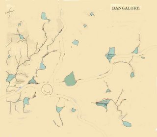
What the area where Bangalore is now would have looked like then is depicted in the rough sketch below.
A king called Kempe Gowda then took over the area and built a small mud fort here along with a few watch towers. He is said to have been an astute planner and built the watch towers as the maximum distance the city would extend to. His great military planning would have served in locating these watch towers, as he has selected relatively high points to build these, so that he could keep a watch over low-lying plains. Thereby enemy troops arriving would have to cross flat land and could be spotted at a distance. Any village beyond those points would have probably beeen difficult to defend.

Shivaji’s father is said to have captured the fort for Adil Shah who gifted it to Shivaji's father. Shivaji marries a Bangalore girl. Later on Aurangzeb’s army captured the fort and sold it to the Wodeyars for around 3 lakhs.
Later the fort was gifted by Wodeyar to Hyder Ali. Hyder Ali strengthened the fort with granite and also built Lalbagh nearby. The strengthening of the fort brought it more into focus and also most probably connecting trails went from it to nearby forts such as the Savanadurg Fort, Srirangapatnam fort (the present Mysore Road?), a trail towards the Devanahalli fort where Tipu was born and the Nandi hills fort (Nandidurg fort) (now Bellary Road??), a trail towards Krishnagiri & Vellore (now Lasker Hosur Road??) and a trail towards Chittoor (now Old Madras Road??)

The area around the fort was supposed to have been barren, as it was most probably laid waste by the defenders so as to have a clear field of vision around the fort.

With the fort now being a stronghold, the British during their time in India targeted it and won it from Tipu. They are supposed to have returned it to Tipu and on his death, gave it to the Wodeyars. The British regiments now moved into the area around it in full strength and plans were laid to convert it into a cantonment. The name also would have got changed to Bangalore.

What would have initially been tent camps on the plains around started getting converted into regular buildings and a large number of Bangalore’s current roads would have been formed around this time.
The Pete and Bazaar would have been the trading areas. The gaol would have initially been located where the Good Shepherd Convent now stands and would have later been shifted to the area which is close to Central College which would have been then on the outskirts of Bangalore. Bangalore was the site of a relatively unknown plot of a few to mutiny against the British much before 1857!!

The General Post Office (GPO) would have been built, the rail line is built and so is the Attara Kacheri (court house) and the Bangalore Palace. Cubbon Park comes up as the lung space. The British administration starts. Parade grounds would have been the maidan for troops to parade. A road would have been laid connecting the cantonment to Hosur Road which is now Brigade Road. The road where Bangalore Club now stands would have been where the British resident had his residence, and is now called Residency Road. A Museum would have been located on what is now Museum Road. A separate race course was made on what is now Race Course Road. Trees would have been planted along roads leading to the roads becoming shady avenues.

The retired and pensioners must have found it a quiet and peaceful town and with a salubrious climate to boot, it would have seemed ideal to settle down in.
An 1863 map.
The first telephone rang soon in the city and also the city was struck by the great plague. A huge city cleanup task was undertaken and new extensions such as Malleswaram were built leading to removal of orchards. Mayo Hall housed the new corporation offices.
India’s first electric bulb flickered to life in the City Market. Tata’s Indian Institute of Science was built near Mekhri Circle. Mekhri Circle takes its name from a benefactor who levelled the steep slope of the now Bellary Road so that the beasts of burden weren't put under a tremendous strain to haul goods up its slope to Bangalore.
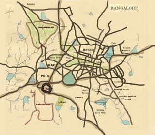
Bangalore in the 1920s
A few years later the first flight (Bangalore-Bombay) takes off. Bangalore starts proceeding in leaps and bounds.
The Deccan Herald, a daily newspaper comes into being, the Vidhana Soudha is constructed. Bangalore had many tanks and lakes.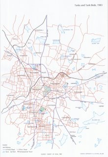
Bangalore’s water was sourced from the Thippagondanahalli reservoir across the River Arkavathi designed by Sir M. Visvesvaraya. Most of Bangalore’s water comes from pipelines laid in valleys so as to use minimum power for pumping water into Bangalore.

Large public sector companies set up shop in Bangalore. Housing colonies for workers are built close to factories.
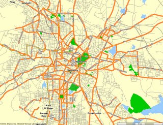
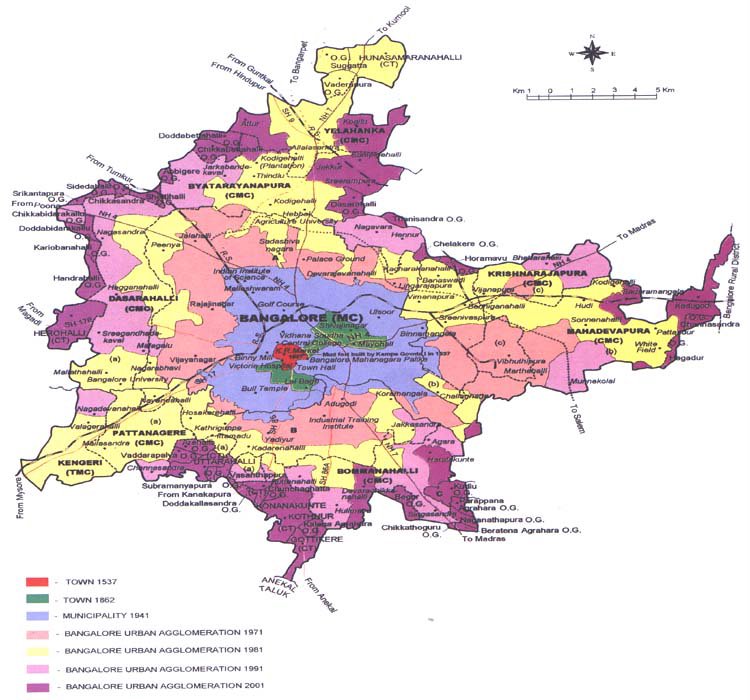
Bangalore the town with a lot of rich history is now a bustling metropolis wherein its popularity has brought in more industries, more people and more pressure on its existing infrastructure.

Bangalore's growth has been phenomenal as can be seen from the chart below.
posted by Sunil Pichamuthu @ 4:09 AM
View Profile | View Main Page | View Photos | Go to Top
4 comments
![]()
![]()